

 Հայերեն
 Русский
 العربية
 فارسی
Road signs
282 signs in 8 groups, with their official numbers and names.
Nothing found
Warning signs inform road users that they are approaching a dangerous section of road, travel (movement) along which requires taking measures appropriate to the situation.
-
 1.1
“Level crossing with barrier”.
-
 1.2
“Level crossing without barrier”.
-
 1.3.1
“Single-track railway”: marking of a level crossing not equipped with a barrier, with one track.
-
 1.3.2
“Multiple-track railway”: marking of a level crossing not equipped with a barrier, with two or more tracks.
-

1.4.1 
1.4.2 
1.4.3 
1.4.4 
1.4.5 
1.4.6 1.4.1 – 1.4.6“Approach to a level crossing”: additional warning of the approach to a level crossing outside built-up areas.
-
 1.5
“Crossing with a tramway”.
-
 1.6
“Intersection of equivalent roads”.
-
 1.7
“Intersection with roundabout traffic”.
-
 1.8
“Traffic signals”: an intersection, pedestrian crossing or section of road where traffic is controlled by traffic lights.
-
 1.9
“Opening bridge”: an opening bridge or a ferry crossing.
-
 1.10
“Exit to embankment”: a place of exit onto an embankment or a bank.
-

1.11.1 
1.11.2 1.11.1 – 1.11.2“Dangerous bend”: a curve of the road with a small radius or with limited visibility: 1.11.1 to the right, 1.11.2 to the left.
-

1.12.1 
1.12.2 1.12.1 – 1.12.2“Dangerous bends”: a section of road with dangerous bends: 1.12.1 with the first bend to the right, 1.12.2 with the first bend to the left.
-
 1.13
“Steep descent”.
-
 1.14
“Steep ascent”.
-
 1.15
“Slippery road”: a section of road with an especially slippery carriageway.
-
 1.16
“Uneven road”: a section of road with irregularities of the carriageway (undulations, potholes, uneven joints with bridges, etc.).
-
 1.17
“Speed hump”: a section of road with an artificial hump (humps) for compulsory reduction of speed.
-
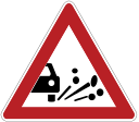 1.18
“Loose gravel”: a section of road where gravel, crushed stone, etc. may be thrown up from under the wheels of vehicles.
-
 1.19
“Dangerous shoulder”: a section of road where driving onto the shoulder is dangerous.
-

1.20.1 
1.20.2 
1.20.3 1.20.1 – 1.20.3“Road narrows”: 1.20.1 narrowing on both sides, 1.20.2 on the right, 1.20.3 on the left.
-
 1.21
“Two-way traffic”: the start of a section of road (carriageway) with oncoming traffic.
-
 1.22
“Pedestrian crossing”.
-
 1.23
“Children”: a section of road passing near children's institutions (schools, kindergartens, etc.), where children may appear on the carriageway.
-
 1.24
“Crossing with a cycle path”.
-
 1.25
“Roadworks”.
-
 1.26
“Livestock crossing”.
-
 1.27
“Wild animals”.
-
 1.28
“Falling rocks”: a section of road where rockfalls, landslides and falling rocks are possible.
-
 1.29
“Crosswind”.
-
 1.30
“Low-flying aircraft”.
-
 1.31
“Tunnel”: a tunnel without artificial lighting, or a tunnel whose entrance portal has limited visibility.
-
 1.32
“Traffic congestion”: a section of road where congestion has formed.
-
 1.33
“Other dangers”: a section of road where there are dangers not covered by the warning signs listed.
-

1.34.1 
1.34.2 1.34.1 – 1.34.2“Direction of turn”: the direction of travel on a small-radius curve of a road with limited visibility; the direction for bypassing a section of road under repair.
-
 1.34.3
“Direction of turn”: the directions of travel at a T-junction or at a fork in the road; the directions for bypassing a section of road under repair.
Note
- Signs 1.1, 1.2 and 1.5-1.33 are installed before the start of the dangerous section at a distance of 150-300 m outside built-up areas and 50-100 m in built-up areas. If necessary, the signs may also be installed at a different distance. In that case the distance is indicated on plate 8.1.1 “Distance to object”.
- Signs 1.1, 1.2, 1.9, 1.10, 1.23 and 1.25 are repeated outside built-up areas. The second (repeated) sign is installed at a distance of not less than 50 m from the start of the dangerous section. Signs 1.23 and 1.25 are also repeated in built-up areas, immediately before the dangerous section.
- Signs 1.13 and 1.14 may be installed without plate 8.1.1 “Distance to object”, immediately before a descent or an ascent, if descents and ascents follow one another.
- When short-term work is carried out on the carriageway, sign 1.25 may be installed without plate 8.1.1 “Distance to object”, at a distance of 10-15 m from the place where the work is being carried out.
- Sign 1.32 is used as a temporary sign or on variable-message signs before an intersection from which it is possible to bypass the section of road where congestion has formed.
Priority signs establish the order of passage through intersections, crossings of carriageways or narrow sections of road
-
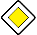 2.1
“Priority road”: a road on which road users are given priority when passing through uncontrolled intersections.
-
 2.2
“End of priority road”.
-
 2.3.1
“Intersection with a minor road”.
-
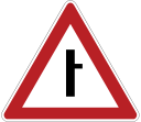
2.3.2 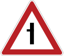
2.3.3 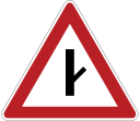
2.3.4 
2.3.5 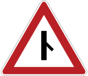
2.3.6 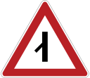
2.3.7 2.3.2 – 2.3.7“Junction with a minor road”: 2.3.2, 2.3.4, 2.3.6 junction on the right, 2.3.3, 2.3.5, 2.3.7 junction on the left.
-
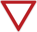 2.4
“Give way”: the driver must give way to vehicles travelling on the road being crossed and, where plate 8.13 “Direction of the priority road” is present, to vehicles travelling on the priority road.
-
 2.5
“Stop”: proceeding without stopping before the “Stop” line (or, if there is none, before the edge of the carriageway being crossed) is prohibited. The driver must give way to vehicles travelling on the road being crossed and, where plate 8.13 “Direction of the priority road” is present, to vehicles travelling on the priority road. If sign 2.5 is installed before a level crossing or a quarantine checkpoint, the driver must stop before the “Stop” line or, if there is none, before the sign.
-
 2.6
“Priority for oncoming traffic”: entering a narrow section of road is prohibited if this may hinder oncoming traffic. The driver must give way to vehicles approaching the narrow section from the opposite direction.
-
 2.7
“Priority over oncoming traffic”: a narrow section of road on which the driver has priority over oncoming vehicles.
Prohibitory signs introduce or cancel certain traffic restrictions.
-
 3.1
“No entry”: vehicles are prohibited from entering in this direction.
-
 3.2
“No vehicles”: the movement of all vehicles is prohibited.
-
 3.3
“No power-driven vehicles”.
-
 3.4
“No goods vehicles”: the movement of goods vehicles and vehicle combinations with a maximum authorised mass of more than 3.5 tonnes (if no mass is indicated on the sign) or more than the mass indicated on the sign, as well as of tractors and self-propelled machines, is prohibited.
-
 3.5
“No motorcycles”.
-
 3.6
“No tractors”: the movement of tractors and self-propelled machines is prohibited.
-
 3.7
“No vehicles with trailers”: the movement of goods vehicles and tractors with trailers of any type, as well as the towing of power-driven vehicles, is prohibited.
-
 3.8
“No animal-drawn vehicles”: the movement of animal-drawn vehicles (sledges), riding or pack animals, and the driving of livestock are prohibited.
-
 3.9
“No bicycles”: the movement of mopeds and bicycles is prohibited.
-
 3.10
“No pedestrians”.
-
 3.11
“Weight limit”: the movement of vehicles (including road trains) whose actual total mass exceeds that indicated on the sign is prohibited.
-
 3.12
“Axle load limit”: the movement of vehicles whose load on any axle exceeds that indicated on the sign is prohibited.
-
 3.13
“Height limit”: the movement of vehicles whose overall height (with or without load) exceeds that indicated on the sign is prohibited.
-
 3.14
“Width limit”: the movement of vehicles whose overall width (with or without load) exceeds that indicated on the sign is prohibited.
-
 3.15
“Length limit”: the movement of vehicles (including road trains) whose overall length (with or without load) exceeds that indicated on the sign is prohibited.
-
 3.16
“Minimum distance limit”: the movement of vehicles is prohibited if the distance between them is less than that indicated on the sign.
-
 3.17.1
“Customs”: passing the customs post without stopping is prohibited.
-
 3.17.2
“Danger”: further movement of all vehicles is prohibited because of a road traffic accident, fire, emergency or other danger, except for vehicles of the police, emergency medical services, rescue services and other services that have arrived to eliminate the danger; movement may be continued only after permission has been obtained.
-
 3.17.3
“Checkpoint”: passing through the checkpoint without stopping is prohibited.
-
 3.18.1
“No right turn”.
-
 3.18.2
“No left turn”.
-
 3.19
“No U-turn”.
-
 3.20
“No overtaking”: overtaking by all types of vehicles is prohibited. Overtaking slow-moving vehicles, animal-drawn vehicles, two-wheeled motorcycles without a sidecar, mopeds and bicycles is permitted.
-
 3.21
“End of no-overtaking zone”.
-
 3.22
“No overtaking by goods vehicles”: overtaking by all types of vehicles is prohibited, except for motorcycles, passenger cars, buses and goods vehicles with a maximum authorised mass of up to 3.5 tonnes.
-
 3.23
“End of no-overtaking zone for goods vehicles”.
-
 3.24
“Maximum speed limit”: driving at a speed (km/h) higher than that indicated on the sign is prohibited.
-
 3.25
“End of maximum speed limit zone”.
-
 3.26
“No audible warning signals”: the use of audible warning signals is prohibited, except when a signal is given to prevent a road traffic accident.
-
 3.27
“No stopping”: stopping and parking of vehicles are prohibited.
-
 3.28
“No parking”: parking of vehicles is prohibited.
-
 3.29
“No parking on odd days of the month”.
-
 3.30
“No parking on even days of the month”: when signs 3.29 and 3.30 are used together, vehicles are moved from one side of the road to the other between 19.00 and 21.00.
-
 3.31
“End of all restrictions zone”: marks the simultaneous end of the zones of application of several of the signs 3.16, 3.20, 3.22, 3.24 and 3.26 - 3.30.
-
 3.32
“No vehicles carrying dangerous goods”: the movement of vehicles bearing the “Dangerous goods” identification sign is prohibited.
-
 3.33
“No vehicles carrying explosive and flammable goods”: the movement of vehicles bearing the “Dangerous goods” identification sign and intended for the carriage of dangerous goods of classes 1, 2.2 - 2.4, 3.1, 3.2 and 5.2 (according to the standard) is prohibited.
Note
- Signs 3.2 - 3.9, 3.32 and 3.33 prohibit the movement of the corresponding types of vehicles in both directions.
- The signs do not apply to:
3.1 - 3.3, 3.18.1, 3.18.2, 3.19: public transport vehicles;
3.2 - 3.8: taxis, vehicles carrying out construction, repair, maintenance or cleaning of roads, servicing and repair of technical means of traffic management, or loading and transport of defective, damaged and other vehicles, special postal vehicles with colour markings, and vehicles that serve facilities located within the zone of application of the signs or that belong to or serve citizens living or working in that zone. In these cases the vehicles must enter and leave the zone at the intersection nearest to the facility;
3.2, 3.3, 3.28 - 3.30: vehicles driven by persons with group I or II disabilities, or carrying persons with group 1 or 2 disabilities or children with the status of a disabled child;
3.28 - 3.30: special postal vehicles with colour markings, and taxis with the meter switched on. - The signs apply:
3.10, 3.27 - 3.30: only to the side of the road on which they are installed;
3.16, 3.20, 3.22, 3.24 and 3.26 - 3.30: from the place where the sign is installed to the nearest intersection after it, and in built-up areas, if there is no intersection, to the end of the built-up area. The effect of the signs is not interrupted at U-turn places and breaks in the dividing strip, or at exits from areas adjacent to the road and at crossings with (junctions with) field, forest and other minor roads, if no corresponding signs are installed before them;
3.18.1 and 3.18.2: to the crossing of carriageways before which the sign is installed;
3.24 (installed before a built-up area marked with sign 5.23.1 or 5.23.2): up to sign 5.23.1 or 5.23.2 “Start of built-up area”. - The zone of application of the signs may be reduced:
for signs 3.16 and 3.26: by using plate 8.2.1 “Zone of application”;
for signs 3.20, 3.22 and 3.24: by installing signs 3.21, 3.23 and 3.25 respectively at the end of their zone of application, or by using plate 8.2.1 “Zone of application”;
for sign 3.24: by installing the same sign 3.24 with a different maximum speed value;
for signs 3.27 - 3.30: by using plate 8.2.2 “Zone of application”, or by repeating the same signs 3.27 - 3.30 respectively, with plate 8.2.3 “Zone of application”, at the end of their zone of application;
sign 3.27 may be used together with road marking 1.4, and sign 3.28 together with road marking 1.10; in this case the zone of application of the signs is determined by the length of the marking.
Mandatory signs show the permitted directions of travel and the minimum speed, and also prescribe the directions of movement for pedestrians and for drivers of certain vehicles.
-
 4.1.1
“Proceed straight on”.
-
 4.1.2
“Proceed right”.
-
 4.1.3
“Proceed left”.
-
 4.1.4
“Proceed straight on or right”.
-
 4.1.5
“Proceed straight on or left”.
-
 4.1.6
“Proceed right or left”: travel is permitted only in the directions shown by the arrows on the signs.
-
 4.2.1
“Pass obstacle on the right”.
-
 4.2.2
“Pass obstacle on the left”: passing is permitted only on the side shown by the arrow.
-
 4.2.3
“Pass obstacle on the right or left”: passing is permitted on both the right and the left side.
-
 4.3
“Roundabout”: travel is permitted in the direction shown by the arrows.
-
 4.4
“Cycle path”: only mopeds and bicycles are permitted. If there is no pavement or footpath, pedestrians may also use the cycle path.
-
 4.5
“Footpath”: only pedestrians are permitted.
-
 4.6
“Minimum speed limit”: travel is permitted only at the indicated speed (km/h) or higher.
-
 4.7
“End of minimum speed limit zone”.
-

4.8.1 
4.8.2 
4.8.3 4.8.1 – 4.8.3“Direction of travel for vehicles carrying dangerous goods”: vehicles bearing the “Dangerous goods” identification sign may travel only in the direction shown by the arrow on the sign: 4.8.1 straight on, 4.8.2 to the right, 4.8.3 to the left.
Note
- Signs permitting a left turn also permit a U-turn (signs 4.1.1 - 4.1.6 may be used with arrows shaped to match the directions of travel at the particular crossing);
signs 4.1.1 - 4.1.6 do not apply to public transport vehicles;
signs 4.1.1 - 4.1.6 apply to the crossing of carriageways before which the sign is installed.
Sign 4.1.1 installed at the start of a section of road applies up to the nearest intersection. The sign does not prohibit a right turn into courtyards and other areas adjacent to the road.
Special regulation signs introduce or cancel certain traffic regimes.
-
 5.1
“Motorway”: a road on which the requirements of the rules establishing the procedure for driving on motorways apply.
-
 5.2
“End of motorway”.
-
 5.3
“Road for motor vehicles”: motorcycles are also permitted.
-
 5.4
“End of road for motor vehicles”.
-
 5.5
“One-way road”: a road or carriageway on which vehicles travel in one direction across its entire width.
-
 5.6
“End of one-way road”.
-

5.7.1 
5.7.2 5.7.1 – 5.7.2“Exit onto a one-way road”: exit onto a one-way road or carriageway.
-
 5.8
“Reversible traffic”: the start of a section of road on which the direction of traffic in one or more lanes may be reversed.
-
 5.9
“End of reversible traffic”.
-
 5.10
“Exit onto a road with reversible traffic”.
-
 5.11
“Road with a lane for public transport vehicles”: a road with a lane specially designated for public transport vehicles travelling against the general flow of traffic.
-
 5.12
“End of road with a lane for public transport vehicles”.
-

5.13.1 
5.13.2 5.13.1 – 5.13.2“Exit onto a road with a lane for public transport vehicles”.
-
 5.14
“Lane for public transport vehicles”: a lane intended only for public transport vehicles travelling in the same direction as the general flow of traffic. The sign applies to the lane above which it is installed. A sign installed on the right side of the road applies to the right-hand lane.
-
 5.15.1
“Directions of traffic by lanes”: the number of lanes and the permitted directions of travel in each of them.
-
 5.15.2
“Directions of traffic in a lane”: the permitted directions of travel in a lane. Signs 5.15.1 and 5.15.2 permitting a left turn from the leftmost lane also permit a U-turn from that lane. Signs 5.15.1 and 5.15.2 do not apply to public transport vehicles. The zone of application of signs 5.8.1 and “5.15.2” installed before an intersection extends to the whole intersection, unless other signs 5.15.1 or 5.8.2 installed there give different instructions.
-
 5.15.3
“Start of lane”: the start of a deceleration lane or of an additional lane on an ascent. If sign 4.6 “Minimum speed limit” is shown on this sign installed before an additional lane, drivers of vehicles that cannot continue in the main lane at least at the speed shown on the sign must move into the additional lane.
-
 5.15.4
“Start of lane”: the start of the section of the middle lane of a three-lane road intended for travel in this direction. If sign 5.15.4 shows a sign prohibiting the movement of any type of vehicle, the movement of those vehicles in the corresponding lanes is prohibited.
-
 5.15.5
“End of lane”: the end of an acceleration lane or of an additional lane on an ascent.
-
 5.15.6
“End of lane”: the end of the section of the middle lane of a three-lane road intended for travel in this direction.
-
 5.15.7
“Directions of traffic by lanes”: if sign 5.15.7 shows a sign prohibiting the movement of any vehicle, the movement of that vehicle in the lane concerned is prohibited. Sign 5.15.7 with the appropriate number of arrows may be used on roads with four or more lanes.
-
 5.15.8
“Number of lanes”: shows the number of traffic lanes and the traffic regimes in the lanes. The driver must comply with the requirements of the signs shown on the arrows.
-
 5.16
“Bus and/or trolleybus stop”.
-
 5.17
“Tram stop”.
-
 5.18
“Taxi parking place”.
-

5.19.1 
5.19.2 5.19.1 – 5.19.2“Pedestrian crossing”: if there are no road markings 1.14.1 - 1.14.2 at the crossing, sign 5.19.1 is installed on the left side of the road at the far boundary of the crossing, and sign 5.19.2 on the right side of the road at the near boundary of the crossing.
-
 5.20
“Speed hump”: shows the boundaries of an artificial hump. The sign is installed at the boundary of the artificial hump nearest to vehicles approaching it.
-
 5.21
“Residential zone”: an area in which the requirements of the rules establishing the procedure for traffic in a residential zone apply.
-
 5.22
“End of residential zone”.
-

5.23.1 
5.23.2 5.23.1 – 5.23.2“Start of built-up area”: the start of a built-up area in which the requirements of the rules establishing the procedure for traffic in built-up areas apply.
-

5.24.1 
5.24.2 5.24.1 – 5.24.2“End of built-up area”: the place from which the requirements of the rules establishing the procedure for traffic in built-up areas cease to apply on this road.
-
 5.25
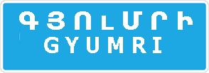
“Start of built-up area”: the name and start of a built-up area in which the requirements of the rules establishing the procedure for traffic in built-up areas do not apply on this road.
-
 5.26
“End of built-up area”: the end of the built-up area marked with sign 5.25.
-
 5.27
“Restricted parking zone”: the place where the area (section of road) in which parking is prohibited begins.
-
 5.28
“End of restricted parking zone”.
-
 5.29
“Controlled parking zone”: the place where the area (section of road) in which parking is permitted and regulated by means of plates and road markings begins.
-
 5.30
“End of controlled parking zone”.
-
 5.31
“Maximum speed limit zone”: the place where the area (section of road) with a maximum speed limit begins.
-
 5.32
“End of maximum speed limit zone”.
-
 5.33
“Pedestrian zone”: the place where the area (section of road) in which only pedestrians are permitted begins.
-
 5.34
“End of pedestrian zone”.
Information signs inform about the location of settlements and other places, as well as about established or recommended traffic regimes.
-
 6.1
“General maximum speed limit”: the general maximum speed limit established by the rules.
-
 6.2
“Recommended speed”: the preferred speed for travel on this section of road. The sign's zone of application extends to the nearest intersection.
-
 6.3.1
“Place for U-turn”: left turns are prohibited.
-
 6.3.2
“U-turn area”: the length of the area for making a U-turn. Left turns are prohibited.
-
 6.4
“Parking place”.
-
 6.5
“Emergency stopping lane”: an emergency stopping lane on a steep descent.
-
 6.6
“Underground pedestrian crossing”.
-
 6.7
“Overhead pedestrian crossing”.
-

6.8.1 
6.8.2 
6.8.3 6.8.1 – 6.8.3“Dead end”: a road with no through route.
-

6.9.1 
6.9.2 6.9.1 – 6.9.26.9.1 “Advance directions sign”, 6.9.2 “Advance direction sign”: the directions of travel to the settlements and other places indicated on the sign. These signs may show the image of sign 6.14.1, motorway and airport symbols and other pictograms.
-
 6.9.3
“Traffic scheme”: the route of travel when certain manoeuvres are prohibited at intersections, or the permitted directions of travel at complex intersections.
-

6.10.1 
6.10.2 6.10.1 – 6.10.26.10.1 “Directions sign”, 6.10.2 “Direction sign”: the directions of travel to points on the route. The signs may indicate the distances (km) to these places and show motorway and airport symbols and other pictograms.
-
 6.11
“Name of object”: the name of a place other than a settlement (river, lake, mountain pass, landmark, etc.).
-
 6.12
“Distance sign”: the distance (km) to the settlements located on the route.
-
 6.13
“Kilometre sign”: the distance (km) to the start or end of the road.
-

6.14.1 
6.14.2 6.14.1 – 6.14.2“Route number”: 6.14.1 the number assigned to the road (route), 6.14.2 the number and direction of the road (route).
-

6.15.1 
6.15.2 
6.15.3 6.15.1 – 6.15.3“Direction of travel for goods vehicles”: the recommended direction of travel for goods vehicles, tractors and self-propelled machines if their movement in any direction is prohibited at the intersection.
-
 6.16
“Stop line”: the place where vehicles stop when a traffic light (traffic controller) shows a prohibiting signal.
-
 6.17
“Detour scheme”: the route for bypassing a section of road temporarily closed to traffic.
-

6.18.1 
6.18.2 
6.18.3 6.18.1 – 6.18.3“Detour direction”: the direction for bypassing a section of road temporarily closed to traffic.
-

6.19.1 
6.19.2 6.19.1 – 6.19.2“Advance sign for changing to another carriageway”: the direction of travel for bypassing a section of a carriageway closed to traffic on a road with a dividing strip, or for returning to the right-hand carriageway.
-

6.20.1 
6.20.2 6.20.1 – 6.20.2“Emergency exit”: shows the place in a tunnel where the emergency exit is located.
-
 6.21.1
“Direction to emergency exit”: shows the direction to the emergency exit and the distance to it.
Service signs inform about the location of the corresponding facilities.
-
 7.1
“First aid post”.
-
 7.2
“Hospital”.
-
 7.3
“Filling station”.
-
 7.4
“Vehicle maintenance”.
-
 7.5
“Car wash”.
-
 7.6
“Telephone”.
-
 7.7
“Eating place”.
-
 7.8
“Drinking water”.
-
 7.9
“Hotel or motel”.
-
 7.10
“Campsite”.
-
 7.11
“Rest area”.
-
 7.12
“Road police patrol service post”.
-
 7.13
“Police”.
-
 7.14
“International road transport control point”.
-
 7.15
“Reception area of a radio station broadcasting road traffic information”.
-
 7.16
“Radio communication zone with emergency services”.
-
 7.17
“Swimming pool or beach”.
-
 7.18
“Toilet”.
-
 7.19
“Emergency telephone”.
-
 7.20
“Fire extinguisher”.
Additional information signs (plates) specify or restrict the effect of the signs with which they are used.
-
 8.1.1
“Distance to object”: shows the distance from the sign, in the direction of travel, to the start of the dangerous section, to the place where the corresponding restriction is introduced, or to a specific object (place) ahead.
-
 8.1.2
“Distance to object”: shows the distance from sign 2.4 “Give way” to the intersection when sign 2.5 “Stop” is installed immediately before the intersection.
-

8.1.3 
8.1.4 8.1.3 – 8.1.4“Distance to object”: shows the distance to an object located off the road.
-
 8.2.1
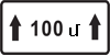
“Zone of application”: shows the length of a dangerous section of road marked with warning signs, or the zone of application of prohibitory and information/direction signs.
-

8.2.2 
8.2.3 
8.2.4 
8.2.5 
8.2.6 8.2.2 – 8.2.6“Zone of application”: the plates show and/or inform about: 1) 8.2.2: the zone of application of prohibitory signs 3.27 “No stopping”, 3.28 “No parking”, 3.29 “No parking on odd days of the month” and 3.30 “No parking on even days of the month”. 2) 8.2.3: the end of the zone of application of signs 3.27 - 3.30. 3) 8.2.4: being within the zone of application of signs 3.27 - 3.30. 4) 8.2.5, 8.2.6: the direction and zone of application of signs 3.27 - 3.30 when stopping or parking is prohibited along one side of a square, a building façade or other places.
-

8.3.1 
8.3.2 
8.3.3 8.3.1 – 8.3.3“Directions of application”: show the directions of application of signs installed before an intersection, or the directions of travel to places located directly next to the road.
-

8.4.1 
8.4.2 
8.4.3 
8.4.4 
8.4.5 
8.4.6 
8.4.7 
8.4.8 8.4.1 – 8.4.8“Type of vehicle”: shows the type of vehicle to which the sign applies. Signs used with these plates apply to: 1) 8.4.1: goods vehicles with a maximum authorised mass of more than 3.5 tonnes, including those operated with a trailer, 2) 8.4.3: passenger cars, as well as goods vehicles with a maximum authorised mass of up to 3.5 tonnes, 3) 8.4.8: vehicles bearing the “Dangerous goods” identification sign.
-

8.5.1 
8.5.2 
8.5.3 8.5.1 – 8.5.38.5.1. “Saturdays, Sundays and public holidays”, 8.5.2. “Working days”, 8.5.3. “Days of the week”: the plates indicate the days of the week on which the sign is in effect.
-

8.5.4 
8.5.5 
8.5.6 
8.5.7 8.5.4 – 8.5.7“Time of operation”: plate 8.5.4 indicates the hours of the day, and plates 8.5.5 – 8.5.7 also the days of the week, during which the sign is in effect.
-

8.6.1 
8.6.2 
8.6.3 
8.6.4 
8.6.5 
8.6.6 
8.6.7 
8.6.8 
8.6.9 8.6.1 – 8.6.9“Method of parking vehicles at parking places”: show the methods of positioning vehicles: 1) 8.6.1: on the carriageway, along the pavement, for all vehicles, 2) 8.6.2 - 8.6.9: at a parking place adjacent to the pavement, for passenger cars and motorcycles.
-
 8.7
“Parking with engine switched off”: shows that at a parking place marked with sign 6.4 “Parking place”, vehicles may be parked only with the engine switched off.
-
 8.8
“Paid services”: indicates that the services provided are subject to a charge.
-
 8.9
“Parking time limit”: indicates the maximum length of time a vehicle may stay at a parking place marked with sign 6.4 “Parking place”.
-
 8.10
“Vehicle inspection place”: indicates that an inspection pit or other facility for inspecting vehicles is available at the area marked with sign 6.4 “Parking place” or 7.11 “Rest area”.
-
 8.11
“Maximum authorised mass limit”: indicates that the sign applies only to vehicles whose maximum authorised mass exceeds that indicated on the plate.
-
 8.12
“Dangerous shoulder”: warns that driving onto the shoulder is dangerous because repair work is being carried out. Used with sign 1.25 “Roadworks”.
-
 8.13
“Direction of the priority road”: shows the direction of the priority road at an intersection.
-
 8.14
“Traffic lane”: shows the traffic lane to which the sign or traffic light applies.
-
 8.15
“Blind pedestrians”: indicates that the pedestrian crossing is used by blind people. Used with signs 1.22, 5.19.1 and 5.19.2 “Pedestrian crossing” and with traffic lights.
-
 8.16
“Wet surface”: indicates that the sign applies only during the period when the surface of the carriageway is wet.
-
 8.17
“Disabled persons”: indicates that sign 6.4 “Parking place” applies only to motorised wheelchairs and to cars bearing the “Disabled” identification sign.
-
 8.18
“Except disabled persons”: indicates that the sign does not apply to motorised wheelchairs and cars bearing the “Disabled” identification sign.
-
 8.19
“Class of dangerous goods”: shows the number of the class (classes) of dangerous goods according to the standard. Used with signs 3.32 “No vehicles carrying dangerous goods” and 4.8.1 - 4.8.3 “Direction of travel for vehicles carrying dangerous goods”.
-

8.20.1 
8.20.2 8.20.1 – 8.20.2“Type of vehicle bogie”: used with sign 3.12 to show the number of closely spaced axles of the vehicle, for each of which the mass indicated on the sign is the maximum permitted.
-

8.21.1 
8.21.2 
8.21.3 8.21.1 – 8.21.3“Type of public transport vehicle”: Used with sign 6.4 to show the areas intended for parking vehicles near metro stations and bus (trolleybus) or tram stops.
-

8.22.1 
8.22.2 
8.22.3 8.22.1 – 8.22.3“Obstacle”: used with signs 4.2.1 – 4.2.3 to show the obstacle and the direction for passing it. The plates are installed directly below the signs with which they are used. If the signs are installed above the carriageway, shoulder or pavement, plates 8.2.2 - 8.2.4 and 8.13 may be installed beside the sign.
Vehicle identification signs show the type of vehicle or particular features of its driver/load. Except for the “Doctor” and “Disabled” identification signs, which are displayed at the driver's discretion, all other signs must be displayed if the circumstance they indicate applies.
-

“Road train”
-

“Speed limit”
-

“Slow-moving vehicle”
-

“Transport of children”
-

“Studded tyres”
-

“Long vehicle”
-

“Deaf driver”
-

“Oversized load”
-

“Dangerous goods”
-
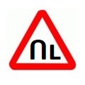
“Training vehicle”
-

“Doctor”
-

“Disabled”